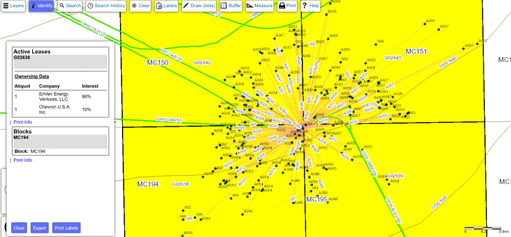
Lease Data
Our Lease Data Report including leasing information on the status of leases along with the geographic locations, effective date, surface acreage and other data elements specific to the lease. We also offer a Lease Owner details lease ownership by percentage and includes the company who is the designated lease operator. And many other lease reports such as P&A Lease Liability, Serial Register search, Active Lease File Document Scanned images (Lease Status, Designation of Operator, Merger/Name Change, Record Title Assigments, Operating Rights, Bonds and more). We also are the only provider to allow a company search for company non-required filings (Liens, Overrides, Mortgages, Financial Statements, and more).
Below is a file layout for Lease Data:
| Field (Abbreviated) Name | Description |
|---|---|
| AREA/BLK | The Area Code and designated OCS Block Number of the well at the surface location. |
| LEASE # | The number assigned to a lease by the regulatory agency have jurisdiction over mineral activity in the territory where the lease is located. |
| WATER DEPTH | The average vertical distance from mean sea level to the sea floor for a block. (Measured in feet) |
| LEASE STATUS | Identifies the development stage of the lease as assigned by the BOEM's Office of Leasing and Environment. |
| STATUS DATE | YYYYMMDD - The date that the development stage of a lease becomes operative. |
| LSE EFFECTIVE DATE | YYYYMMDD - The date a lease becomes operative as assigned by the BOEM. |
| LSE TERM | The initial period (in years) of a lease. |
| EXPECTED EXPIR DT | YYYYMMDD - The anticipated day, month, and year on which the lease is scheduled to expire. |
| SALE # | The number designation assigned by the Minerals Management Service to specifically identify an Outer Continental Shelf lease sale. |
| ACTUAL EXPIR DT | YYYYMMDD - The date a lease expires, is relinquished or terminated. |
| BID SYSTEM | Indicates the method by which royalties are determined for a lease or potential lease. |
| ROYALTY RATE | Specified minimum annual royalty required from the leasehold. |
| API ST CTY | A five-digit number identifier assigned to offshore Federal water areas, as recommended by API., consisting of a two digit state code, a three digit county code. This code becomes a part of the API well number. |
| INITIAL ACRES | The original surface area of a leasehold, unit, etc. |
| CURRENT ACRES | The current total surface area of a leasehold including any assingnments or changes thereto. |
| RENT | The rent per unit of area payable by the lessee on the first day of each lease year prior to discovery of minerals in paying quantity, on the leasehold. |
| BONUS | A timely, sealed submittal to a mineral owner offering a monetary consideration for a specific property during a lease sale. |
| BID/UNIT | The dollar amount of the bid received for a tract divided by the areal amount of the tract. |
| PLAN AREA | Indicates an Outer Continental Shelf (OCS) group of offshore blocks that considered an entity for administrative planning purposes. |
| SUSP EXPIR | YYYYMMDD - The day, month, and year that a lease suspension of production or suspension of operations expires. |
| SUSP TYPE | Indicates whether the lease is help by a suspension of production or suspension of operations |
| SUSP EFFECT DT | YYYYMMDD - The day, month, and year that a suspension of production or suspension of operations holding a lease becomes operative. |
| QUAL WELL (250.11) | The name assigned to the well that is determined to be producible under Title 30 CFR 250.11, and therefore qualifies a lease as producible. |
| QUAL TYPE | Indicates the type of well that is determined to be producible under Title 30 CFR 250.11, and therefore qualifies a lease as producible. C=Completion; L=Determination; P=Production; T=Test. |
| QUAL DATE | The day, month, and year that a lease is determined capable of production in paying quantities as established by the Minerals Management Service. |
| DISCOV TYPE | Indicates the type of mineral deposit discovered on a lease. |
| NEW FIELD (Y/N) | Y= a new field is discovered; N= an extension of an existing field. |
| #PLATFORMS | Number of platforms located on a lease. |
| PLAT APPROV DT | YYYYMMDD - The date the first platform is approved by the Minerals Management Service for a lease. |
| PLAT SET DT | YYYYMMDD - The date that the first platform on a lease was installed. |
| FIRST PROD DT | YYYYMMDD - The date a lease is first placed on continuous extraction of solid minerals or flow of fluid minerals that is primarily for sale rather than for testing. |
We also offer mapping of Lease Data as well as area/block, platforms, wells, pipelines, units and more.